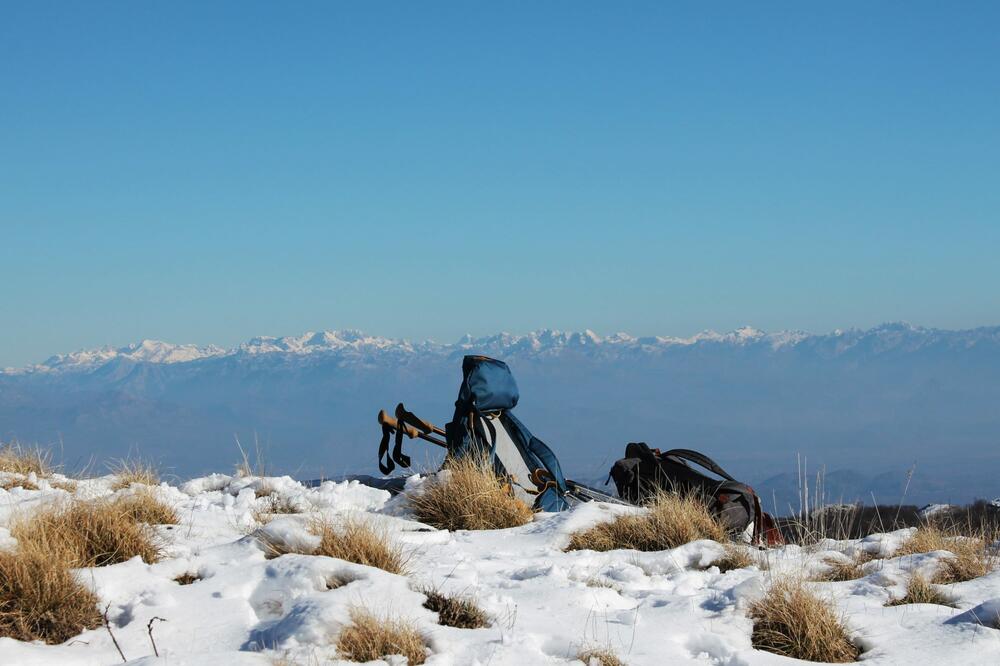
The view from Kuliješ Village is beautiful, no doubt. On one side, you can see the sea and coastline, focusing on the Budva Riviera; on another, the Rumija massif; on the third, the view stretches to the Prokletije mountains, and on the fourth, towards Jezerski Vrh and Štirovnik.
It’s not that I haven’t walked around Lovćen – quite the opposite. But these were mostly outings with a little walking and a lot more driving from viewpoint to viewpoint, visits to the Mausoleum, or, most often, relaxing at Ivanova Korita. Whenever I’m unsure where to go for a day or at least a few hours in nature, Lovćen always seems like the best solution, especially on hot summer days. That’s why one of my first beginner stories, from 9 years ago, was dedicated to Lovćen. It took eight years before my next story from the Lovćen massif – a piece about the fantastic Koložun ridges. I decided to make up for that. In mid-January, I started my hiking year by climbing Kuliješ, the southernmost peak of Lovćen.
Following the numerous hikers and friends on social media, I saw that members of the Mountaineering Society "Soko" from Cetinje had marked the trail and renewed signs on this route. I read on Predrag Popović's page “Peaks of Montenegro” where to start. Saturday, fortunately, was dry and sunny, with all the right conditions to meet Kuliješ. We had our sights on it since our last tour of Paštrovski Vrh Goli Vrh. Sanja even hoped we’d “sprint” to both peaks on that day, but we had to wait another month.

To reach both peaks, head to Brajići. For Goli Vrh, turn left towards the Kosmač fortress (coming from Podgorica), while for Kuliješ, continue slightly further and turn right towards the village of Stojanovići. The village is at an altitude of 834 meters, and we had to climb another 523 meters to the peak. We immediately noticed that the trail was well-maintained, and Sanja and I commended the hardworking volunteers, even though they couldn’t hear us then, but can read it now.

Along the way, we kept glancing to the left, where we could vaguely see part of the coast from Bečići to Sveti Stefan with the mountain backdrop. Although it was mid-January, we encountered only small patches of snow here and there. Only at the very end was there enough to cover the ground. The sky was clear, an ideal day for hiking.

Before the final ascent, we heard a loud buzzing sound that puzzled us. Soon, we saw massive power lines, and the buzzing grew louder. Admittedly, passing beneath them was unsettling. I wasn’t sure if there was any radiation or danger, but it felt like something best avoided. We hurried on and distanced ourselves.

In our rush, we lost the trail markers. Though the peak was close, we all reached it in our way. The rocks were snow-covered, not enough to cushion the steps, but enough to obscure the path, so I slowed down. We spotted paragliders, as we had a month earlier from Goli Vrh. This activity is clearly popular here. Though they were too far for my lens, I managed to capture one.

Soon, we reached the (lower) peak of Kuliješ. Realizing that the higher peak offered no better view, we didn’t go further. On Kuliješ, there’s a massive "billboard" visible from afar, marking the peak’s name. I asked friends on social media about it and received several explanations. Maybe they all relate to the same thing, but I didn’t understand as a layperson. Mainly, it’s either a radio beacon or something aiding flight control at Tivat airport.

The view from Kuliješ is beautiful. On one side, you see the sea and coastline focusing on the Budva Riviera; on another, the Rumija massif; on the third, the view extends to the Prokletije; and on the fourth, towards Jezerski Vrh and Štirovnik. The sun’s position didn’t favor viewing or photography, and the air towards the sea was not clear, but we were still quite pleased.
We descended to Stojanovići even more lightly than we had climbed. The 523 meters didn’t feel challenging. This tour suits those not overly ambitious, lacking strong fitness, yet love a beautiful view. I count myself in this group. Since we were already at Brajići, we headed to Cetinje for krempitas at Gradska.
I’d heard long ago of a periodic lake on Lovćen called Jezero, but never had the chance to see it. I’d missed several opportunities, so after learning in December that it had water, we decided to visit. I received detailed directions from my friend Zoga, a Lovćen expert. He even warned me about potential wrong turns, but it was in vain – we still missed it.
The lake lies behind Njegoš’s Mausoleum on Jezerski Vrh. Only after learning about it did the peak’s name make sense. The lake fills with water from melting snow from Lovćen and nearby peaks. But, as I said, we missed it. After reaching the junction dividing the roads to Njeguši and Bukovica, we were certain. We turned back, though we didn’t have much time, and were satisfied with our walk. The day was cloudy but calm, and Lovćen looked like autumn rather than the day before New Year’s. The trail through the forest was peaceful and quiet, our steps crunching into dry leaves, with occasional lovely views of the surroundings. We didn’t mind missing the lake. “There’ll be another chance!”

Our chance came in early March. Snow had fallen in the meantime, but we hoped, armed with past experience, to finally reach Lovćen’s lake. At the bus parking lot below Njegoš's Mausoleum, we left the car, walked ahead a few dozen meters, and turned right, as the sign indicated. The trail was covered in snow this time, unlike the last. Noticing we’d left our poles behind for some reason, I nearly gave up. The path slopes slightly, and snow and I aren’t friends. After some hesitation, we set off. I found a dry stick to keep me from tumbling toward Cetinje.
This time, we followed the upper trail and saw the lake through the trees. Soon after, I carefully descended with my stick’s help. I immediately noticed remnants of fortifications and paths. There’s no doubt – the Austrians once reached here. While not a spectacle, it’s nice to discover another natural feature of our country. Many would swear Lovćen has no lake.

On the National Parks page, I read: Jezero – the only lake on Lovćen and a center of biodiversity for European herpetofauna (herpetological reserve). The lake beneath Jezerski Vrh hosts unique herpetofauna with endemics and relics from different geological periods and various degrees of endemism. It is the habitat of endemic species like the small newt and yellow-bellied toad.
It’s certainly remarkable to be a reserve with endemic and relic amphibians and reptiles. Admittedly, we didn’t see any of that. We were captivated by the scenery, the rocks, and knowing Jezerski Vrh was above us. It’s best to come here during snowmelt on Lovćen. The lake might expand, but we were content with what we found. We walked around, alternating between gazing at the lake and the surrounding heights. We even saw an animal track, but we bravely ignored it – likely until face-to-face with one.

Near Jezerski Vrh is Goliš, the fourth-highest Lovćen peak, offering the best view of Jezero. We had no intention of climbing it. Everything was slippery, and we were without poles. Rain began to drizzle. I even crossed Goliš off my list when Sanja mentioned how exhausting the climb had been for her. If it was tough for her, it’s unreachable for me. In any case, I finally reached another lake for my “All Montenegro’s Lakes” gallery.
On the way back, a half-hour from the parking area, we paused to see what we could from this side. We even glimpsed Podgorica.
Kuliješ is located around 20 km from Cetinje, 50 km from Podgorica Airport (Montenegro), 40 km from Tivat Airport (Montenegro), 125 km from Ćilipi Airport in Dubrovnik (Croatia), and 215 km from Tirana Airport (Albania).
Translation is AI genarated
Bonus video:


