I can’t remember the last time I went three months without going on a single tour. Driving doesn’t count. A beautiful day was forecasted for Saturday, with rain on Sunday. We had to seize the opportunity. Sanja came up with an idea: “Oh! There’s a new, really good trail in Malesija. ‘Gorica’ went there.” She showed me a post from the Gorica Mountaineering Society and two or three other articles about the trail preparations. That was enough for me. It was up to Duško’s knee to decide. Tired of waiting in the lowlands, it gave the green light for us to prepare. Sanja’s task was to find the starting point. She hoped that, once we reached Tuzi, the village of Traboin, the starting point of this tour, would appear on Google Maps. But it didn’t. Then our phones took over. Duško and I simultaneously received directions – he from his colleague Toni, and I from my friend Beni. At the intersection near the Tuzi market, we turned left towards the village of Skorać.
I don’t remember passing here before, though I’d heard of Skorać. But Traboin was a new name for me. After all this time and countless kilometers, I still discover places for the first time. As soon as we moved a little past Tuzi, green valleys appeared on the right, with more or fewer houses. “If the tour is known by the first impression, this will be a hit,” we concluded together.

Following the directions, we continued towards Traboin without stopping, deciding to photograph interesting details on the way back. At one point, we saw a sign pointing to the right, so we followed it, only to end up in a house’s yard. Duško got out to ask and learned that the main part of the village was just ahead, without turning. When he turned the key in the ignition – silence. The worst – the car broke down, and we hadn’t even reached the starting point. Seeing it wasn’t the battery, Duško diagnosed the issue as the starter. Luckily, there was a space nearby. We pushed the car back, turned it around, and rolled downhill. It started up! Sanja and I stayed silent, expecting to return home. However, the driver continued towards Traboin.

Here, Sanja’s research paid off. As soon as she spotted the blue sign “Traboin” on a post, she commanded a stop. We parked on an incline to ensure an easier start on the return. Sanja looked around, confused. “This is the sign, but the writing is missing. I know it was here.” Surprisingly, we had internet access and found a post mentioning the vandalism of trail markers here. We were taken aback. Since we knew we had to start on a wide path uphill, we spotted some painted-over markers, though the bright color still showed through the paint, making the effort seem pointless.

Our thoughts on who might’ve done this and why only lasted a few minutes before we immersed ourselves in the surroundings. Soon, we could see Traboin village below us – incredibly beautiful and populated, though I’d only just heard of it.

The trail kept amazing us. It mostly wound through forest (denser or sparser). On at least one side, there was a moss-covered stone wall built using the ancient dry stone technique. Throughout the walk, we passed numerous wild orchids that I’ve adored since my youth. I stopped every few meters to photograph flowers, while Sanja couldn’t take her eyes off the stone walls. With perfect weather, we steadily climbed the slopes of Čemer towards the Grzoja Cave, our final destination.

Walking just over 5 km on a well-cleared and marked trail (with kilometer markers showing remaining distance), we encountered various features that caught our attention. We passed several benches with trash bins and project signage, an effort to attract local and foreign hikers. The benches were useful, especially near viewpoints or springs, but trash cans felt unnecessary – each hiker should carry out their trash. Unless there’s a plan for emptying them, it’s better to leave none. The spring, well, and water spout from the rock were great stops, as were the stone walls and flowers.

Upon exiting the forest, we found brick and concrete building remnants, different from the other stone buildings, leading us to believe they were remnants of the Čemer guard post. From here to the cave, there was no forest or wide path. Still, the path was good, well-trodden, and well-marked. The views opened up – we saw parts of the village across Cijevna, the Kučke mountains, Prekornica, and Albanian mountains. It was clear, though visibility could’ve been better. Combining our knowledge with a navigation app, we recognized several features.

Just before Grzoja Cave, we encountered a small crater reminiscent of similar terrain on Garač Mountain. The walls were rocky, with a soil base from which trees sprouted. Photos don’t do it justice.

A sign on a rock marked the direction to the cave, though the descent looked steep and slippery. Duško opted to wait by the sign, but I carefully ventured down. The path was narrow and required some improvisation, resulting in muddy pants. I admired the moss-covered rocks. Near the end, I almost gave up, facing a low, narrow passage. But guessing it was the last obstacle, I pushed through somehow.


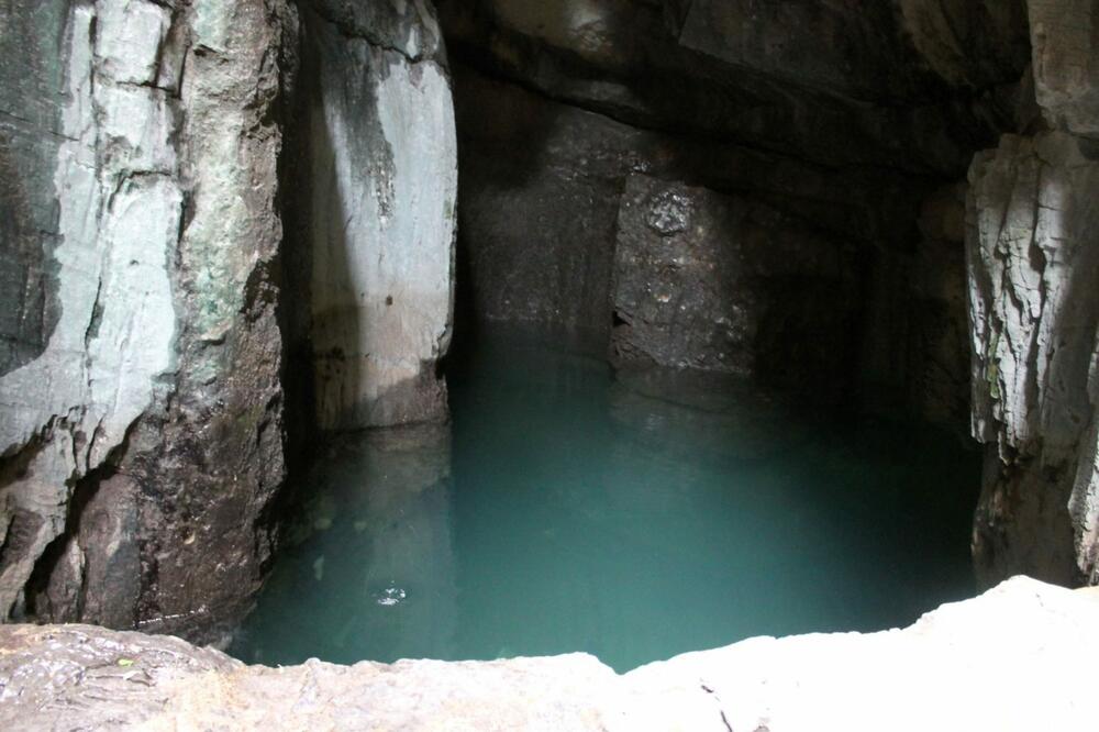
Upon passing through, I found myself in the heart of the cave, taken aback. At the top were three openings, two connected by a bridge, as I’d read. Nearby stood a vertical wall seemingly built from uniform blocks. Unlike typical caves, there were no decorations, but every part of the rock wall had different colors and textures. Two water basins, especially one with turquoise water, were mesmerizing. I fretted over my camera’s inability to capture the beauty, while Sanja lamented Duško missing out. After repeated admiration and countless photos, it was time to leave. Luckily, the return was easier.

Back with Duško, Sanja searched for a viewpoint over the Cijevna canyon, as seen in “Gorica’s” photos, but we hadn’t found it. She couldn’t enjoy what we’d seen until all the pieces fit. I hoped it would appear somewhere. We climbed further above the cave, though there were no more markers. Again, we had the same views towards Skadar Lake, the mountains, Dečić, Tuzi, and Šipčanik. We scrambled up some rocks and caught a glimpse of the Cijevna river. It was a shame the air wasn’t clearer, as everything was visible, though through a haze.

We retraced our steps, stopping at the same spots: each flower, the well, and a pretty meadow. “Wait, wait… There’s a trail across the meadow. There must be something there,” I said, not checking if they followed. Success! The viewpoint! Sanja was thrilled, finally completing the tour. The viewpoint had two benches in just the right spot. Across from us, slightly to the left, was the village of Selište. To the right, the Albanian mountains. I even spotted Grebenit, though fog blocked Berizdolit. We’d climbed those Prokletije peaks a few years ago, so seeing them was like meeting an old friend.

We encountered more stone walls and fortifications. A text about this trail had mentioned a wall reminding me of Vališta’s wall with a clock. Duško and Sanja insisted it was just an ordinary wall, but I was as persistent as Sanja about the viewpoint. Suddenly, there it was. We’d missed it on the way in. Though scratched by brambles and stumbling over stones, we found the perfect angle to capture this unique two-story wall in such a location. Amazing!

The last stretch of the trail passed through the forest and beside dry stone walls. Walking and numerous stops took over six hours. We weren’t tired. On the way back, I took a photo of Skorać through the window, not daring to risk turning off the car. Summing up the tour, “phenomenal” and “fantastic” were the words of the day. All praise to Touristic organisation Tuzi and all project partners. Our only suggestion: a sign towards the viewpoint would be helpful for passersby.
Throughout, I mentioned the wild orchids and took countless photos. It wouldn’t be fair not to share at least one of these beauties. My biggest challenge was choosing, as each was the most beautiful to me.

Hoti Hill is located around 3 km from Tuzi, 14 km from Podgorica Airport (Montenegro), 95 km from Tivat Airport (Montenegro), 171 km from Ćilipi Airport in Dubrovnik (Croatia), and 135 km from Tirana Airport (Albania).
Translation is AI genarated
Bonus video:


